Northern Colorado Wildfires of 2020
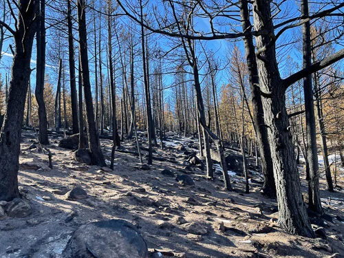
View of burned trees in Upper Beaver Meadows, RMNP, 12/2020
Photos and text by Rachel Ames, Estes Valley Watershed Coalition Board Member
The Estes Valley Watershed Coalition has three main goals – healthy water, healthy forests and healthy wildlife. Of course, they are all interconnected and each ecosystem has its unique challenges. For many of us, the summer 2020 wildfire season is a distant memory, but for some, it is an ongoing burden. This summer and fall showed us what happens when forests are stressed. While one can point the “blame game” at forest management or historic wildfire suppression, that really isn’t helpful at this point. Let’s look at what happened.
Last year’s fire season was the culmination of many factors with a huge dose of luck (or un-luck). First, many of you might remember the drought of the early 2000’s. Drought, along with warm temperatures, led to a large pine beetle outbreak (including spruce and fir beetle). Lots of trees died and when this year’s drought came along, this led to very dry timber. For example, Sheriff Justin Smith posted on his 10/28/2020 Facebook page about how dry the fuels were. He posted, “For the last few days, I’ve been participating in calls between the USFS and Sheriffs to discuss forest conditions and long range weather forecasts. Today we discussed reported fuel moisture in the heavy (1,000 hour) fuels. In 2012 when we had the a High Park, Woodland Heights and the late Fern Lake Fires, that moisture content was reported around 12%, which is roughly the equivalent of kiln dried lumber. However, we were told that current readings around the Arapaho-Roosevelt Forest are coming in in the 6-8% range and that is not expected to change in the near future.” I’ve been measuring rainfall for Community Collaborative Rain, Hail and Snow Network (CoCoRaHS) for several years now and last year’s rainfall was deceptive. We would get big precipitation events but have long dry spells in between. All “seemed” ok until about August when the monsoon moisture never came. The big snow in early September looked like it would calm things down, but it did not last. A warm, dry late September followed by a very warm and dry October made conditions ripe for more wildfires. All it took was a spark and strong winds, and the rest is history.
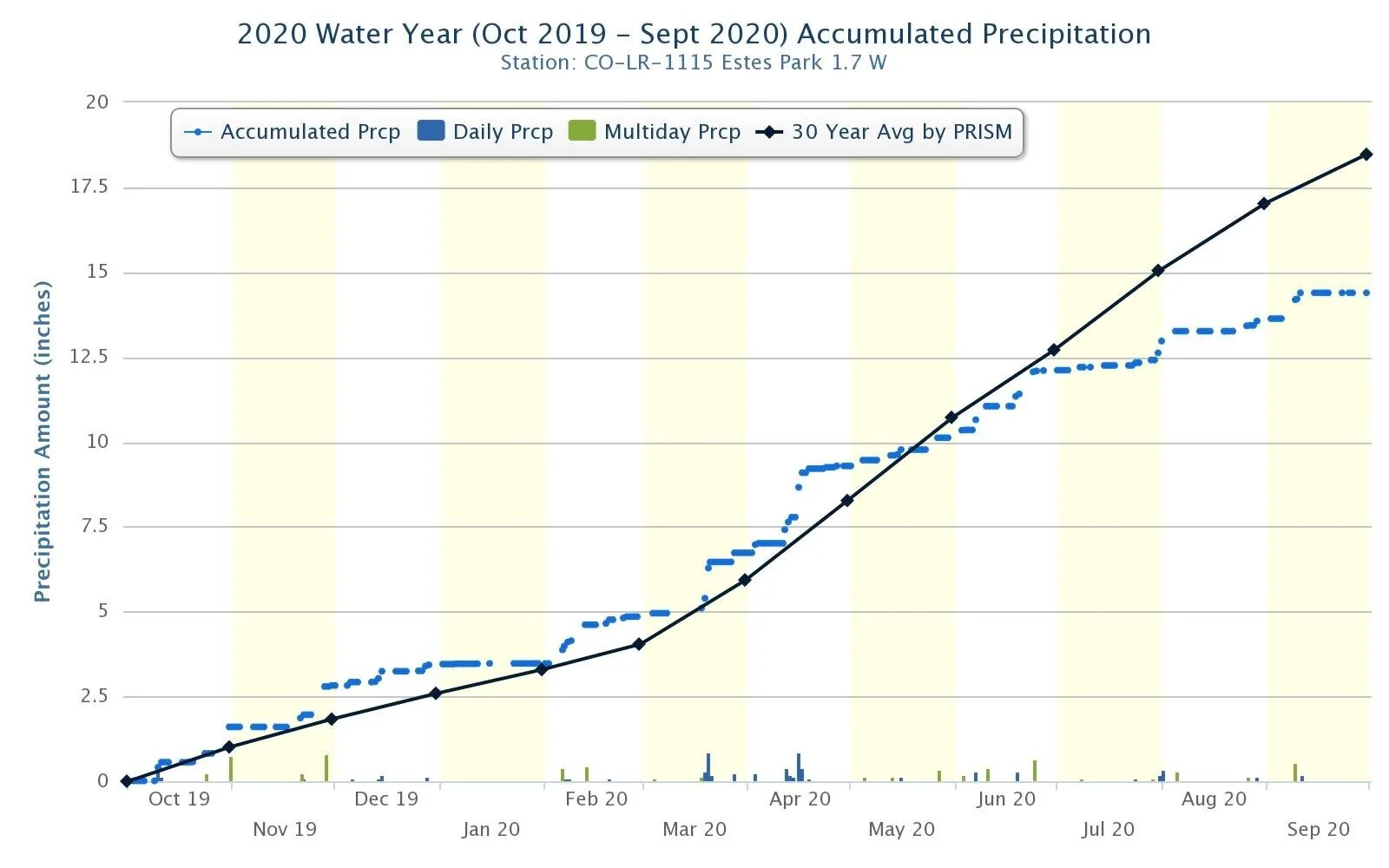
Chart showing accumulated precipitation amount from a CoCoRaHS station near Beaver Meadows Visitor Center
Below, I’ve listed many links to interesting articles and great websites about the forest fires from this past fire season. I hope you will peruse them and find what information is interesting for you. I’ve started the section with some basic facts about the two fires that affected the Estes Valley. There is also a section about what you can do to protect yourself and home from future wildfires. And lastly, if you or someone you know needs to be connected with resources to recover from last year’s fires, I’ve included a section on current recovery effort. If you know about any resources that aren’t included here, please feel free to contact EVWC so that we can include it for others.
Now, let’s hope for some more snow!

Cameron Peak and East Troublesome (and Cal-Wood) wildfires from inciweb.nwcg.gov.
Cameron Peak and East Troublesome Wildfire Quick Facts:
The Cameron Peak and East Troublesome Fires are the #1 and #2 largest fires in Colorado history. For perspective, the entire Rocky Mountain National Park is 358 square miles. The Cameron Peak Fire was about 326 square miles and the East Troublesome Fire was about 303 square miles.
The top 10 largest wildfires in Colorado have been since 2002.
According to the Colorado Water Center at CSU
May 2020 was the 4th warmest on record and August was 1st warmest on record.
April 2020 was the 7th driest on record and August 2020 was the 5th driest on record.
While both fires were actively suppressed, the weather (high winds), terrain (steep and remote areas) and fuel types (dead and dry timber) made suppression efforts difficult at times.
Cameron Peak Fire: 8/13/2020 – 12/2/2020
208,663 acres (about 326 square miles)
9/6-8/2020 — 70,000 acres burned, high winds spread it, and snow stopped it.
$134,000,000 to fight.
469 structures (includes 224 residences) burned.
East Troublesome Fire: 10/14/2020 – 11/30/2020
193,812 acres (about 303 square miles)
Most active period was from the afternoon 10/21/2020 – afternoon 10/22/2020 when 87,093 acres burned at a rate of 6,000 acres/hr.
From 10/20/2020 to 10/23/2020 the fire grew from 18,550 acres to 187,964 acres.
Fire was fueled by widespread drought, dead and downed beetle-killed trees, red flag weather conditions created by high winds and low humidity, poor humidity recovery (rise) overnight led to unprecedented wind-driven active fire behavior and rapid growth over overnight hours. (https://inciweb.nwcg.gov/incident/7242/) Normally winds die down and humidity increases overnight but this did not happen during this period.
366 residences and 214 outbuildings were lost.
Fire resources and interesting articles:
Colorado Sun article on Colorado Wildfire History: https://coloradosun.com/2020/10/20/colorado-largest-wildfire-history/
Colorado Forest Service: 2019 Insect and Disease Update: https://csurams.maps.arcgis.com/apps/MapJournal/index.html?appid=7d49022bff5a49a099c63320d421ea36
2019 Forest Health Report Story Map (shows how the current Spruce Beetle infestation is affecting RMNP are surrounding areas). https://csfs.colostate.edu/forest-management/2019-forest-health-report-story-map/

Colorado Forest Restoration Institute – Fire behaves differently in different forest types: https://cfri.colostate.edu/wp-content/uploads/sites/22/2021/01/FireEd-Infographic-Web_Print-1.pdf
US Forest Service, Rocky Mountain Research Station. Lots of great webinars on forest health. https://www.fs.usda.gov/rmrs/events/webinars
Cameron Peak BAER (Burn Area Emergency Response) Report: https://inciweb.nwcg.gov/photos/COARF/2020-09-20-1235-Cameron-Peak-PostFire-BAER/related_files/pict20201117-152815-0.pdf
Living in the Wildland Urban Interface and Preparing for the Next Wildfire
Living in the Wildland Urban Interface: https://www.estesvalleyfire.org/living-in-the-wui
Estes Valley Fire Protection District: https://www.estesvalleyfire.org/wildfire
Boulder County Wildfire Preparedness Brochure:
Colorado State Forest Service - Management Practices for Different Forest Types: https://csfs.colostate.edu/forest-management/#1465417421331-ebba1e6f-66a0
US Department of Agriculture Learn from the Burn: The High Park Fire 5 Years Later: https://www.fs.fed.us/rm/pubs_journals/2017/rmrs_2017_miller_s003.pdf
Recovery from Wildfire
Larimer Connects (tons of resources for those impacted by the fires or by COVID): https://www.larimer.org/emergency/larimer-connects
Post-Fire Land Rehabilitation FAQ: https://www.larimer.org/sites/default/files/uploads/2020/nrcs_post-fire_land_rehabilitation_faq.pdf